
Common Questions & Answers
FAQs
What will the mine and area look like?
The video below shows a flyover rendering of the mine and surrounding area. The brown areas next to the pit denote the maximum extent of the non-ore bearing rock and spoils if none of the material is utilized off-site. If some of the material can be used as construction aggregate, the footprint and elevation of those areas will be significantly smaller. All disturbed areas will be covered with topsoil and revegetated to reclaim the site.
How long will the mine last?
Based upon the size of the known ore body, the mine would produce ore for about eight-years and process ore for an additional two-years. Including an 18-month construction and 2-year reclamation phases, the entire operation would last approximately 15 years. Drilling has indicated some additional mineral resources that could extend the life of the mine by two-years, but the overall ore body is tightly contained and there have been no signs of significant mineralization beyond the current mine footprint.
Will the mine expand into new areas?
While there are other known mineral deposits and historic mine workings in the area, U.S. Gold Corp holds leases from the State of Wyoming for the areas outlined in yellow on the map below. Existing data shows economically recoverable reserves within a confined area on Section 36 and a small portion of Section 25. There are no current plans to mine outside of this area.

How much water will the mine use?
The project would need between approximately 600 gallons per minute (gpm). To put this into perspective, an agricultural irrigation center pivot covering a 130 acre field uses about 1,000 gallons per minute.
Where will the water come from?
U.S. Gold Corp has signed an agreement to obtain up to 600 gpm water through 2037 from the Cheyenne Board of Public Utilities (BOPU), which is the water and sewer department for the City of Cheyenne. Some of the BOPU owned water infrastructure, including pipelines and reservoirs, are located very close to the project site. With a large industrial user in Cheyenne changing its operations and reducing its water needs, BOPU has excess water available in the short term, which will provide about $15 million over the life of the project. BOPU has indicated they intend to use this revenue to find new sources of water.
The agreement requires the project to cease water use in the event of curtailment or water shortages, ensuring uninterrupted supplies for Cheyenne water users. If the mine wishes to continue operations under these conditions, it would need to secure an alternative supply of water. These needs could be met by accessing unused water allocations, transferring existing irrigation rights to mine use, developing other water sources to replace water taken from the BOPU system, or a combination of these options.
With the exception of a small well at the mine site to provide water for domestic use in the office, shop and plant buildings, there are no plans for additional water wells on the site as the hydrology in the area had indicated minimal ground water availability.
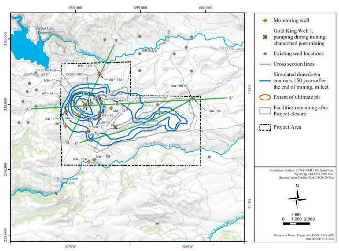
What will the mine do to my water well?
Neirbo Hydrology conducted a wide-ranging study of the area outlined in the map below to understand and model ground water flows. The analysis and modeling shows limited or no impact to area water wells. As the mine pit will be in solid granite, which is very impermeable to water, the impacts are isolated to the project area and nearby wells will see no impact to their water volumes or quality.
Hydrological model showing the extent of groundwater impacts
Will the mine use cyanide heap leaching?
While low grade cyanide is safely used in mining operations in the United States, current plans use froth flotation to extract the target minerals. The processes at CK Gold Project do not use cyanide.
What is the potential for acid mine drainage?
Acid mine drainage is the formation of acidic water through a chemical reaction when surface water flows over rocks containing sulfur bearing minerals. Geochemical analysis has determined the rock chemistry to be net neutral. Humidity cell testing has confirmed conditions do not exist which would cause the rocks to turn acidic and data shows the rock chemistry to be stable.
Tailings dams have been known to fail, will there be a tailings pond?
The CK Gold Project will not have a tailings dam or pond. Dry stacked tailings would be mixed with non-ore bearing rock to create a very stable mixture that would be stacked, contoured, covered in topsoil, and revegetated into the final reclamation topography.
How many employees will there be?
Peak construction employment is estimated at 349 with 255 permanent full-time employees during active mining operations. About 122 employees will be working on the site at any one time. Experience shows that for every mine job there are at least five indirect jobs created. Indirect jobs are those that support the mine operations, such as fuel delivery drivers, maintenance workers and security.
Where will the workers come from?
We anticipate the employees would reside in and around the communities in southeastern Wyoming. U.S. Gold Corp has shared information about the workforce expectations with local officials and will work with communities to ensure the proper resources are in place to support the mine’s workforce. The Industrial Siting Permit process looks extensively at community impacts and can provide resources to help mitigate needs.
Is the company giving preference to Wyoming based contractors?
Wyoming is home to robust mining industry and therefore many mining support companies are located in the state. U.S. Gold Corp’s philosophy is to utilize local companies and is already employing a number of Wyoming based contractors during the development phase. As the processes moves forward, the company will continue to look for opportunities to utilize Wyoming companies.
Is living near a mine harmful?
There are many examples from around the world where people safely live in communities adjacent to mines without impacts.

The community of Lead, SD surrounds the former Homestake Mine. The City of Deadwood is located less than three miles away and hosts over 1.5 million tourists per year.

About 30,000 people live in the city of Kalgoorie, which is located next to an active gold mine in Australia
How much traffic will there be?
The CK Gold Project is reviewing a number of road options. Recognizing the high volume of vehicles that currently travel Happy Jack Road and the fact that County Road 210 is unpaved and currently not well suited for additional traffic, the company would employ several strategies to minimize traffic and keep the roadways safe. There will be one new access road from the north, shown on the map below. U.S. Gold Corp will likely pave the two-mile section of County Road 210 from Happy Jack Road to the access road entrance if the mine moves into production. Employees would travel to a central parking lot in Cheyenne and busses would transport workers to and from the site. There would be some light truck traffic including truckloads of concentrate leaving and deliveries of fuel and other supplies onto the site.

What will the site look like after mining?
The mine plan would determine the final topography and contours, but all tailings and disturbed areas would be capped with topsoil and revegetated to return the site to its pre-mining use, which is livestock grazing. The pit may be filled in or could be utilized as a new water reservoir.

The Portsmouth Mine Pit Lake is a former iron ore mine, which is now a recreational area stocked with brook and rainbow trout.
Will the site be open to the public?
No. All access to the site would be controlled, staffed by a security contractor, and only approved personnel would be allowed to enter the mine area. Mines are regulated by the Mine Health and Safety Administration (MSHA), and they have very strict guidelines on safety and access. For example, only personnel who have completed the required MSHA safety courses are allowed to drive within the permit boundary.
What impact will the mine have on emergency services?
The mine would maintain their own firefighting and EMS equipment, and train personnel to perform emergency services. In the event of a medical emergency, the appropriate mine personnel would attend to the matter and if necessary, transport people to the nearest hospital. The mine could request and offer mutual aid assistance with other first responder units if necessary.
Who receives the taxes and royalties?
Wyoming’s revenue structure is heavily dependent upon taxing natural resources. Just like any other extractive industry, the CK Gold Project would pay royalties, severance, gross proceeds taxes on the value of production, ad valorem property taxes on the value of the equipment and structures, and sales and use taxes on purchases.
The majority of mine area is located on State Section 36, which is a state-owned school trust land. When Wyoming became a state in 1890, the federal government granted the state two sections out of every township, which comprise of 36 sections. The Wyoming Constitution and state laws direct the Board of Land Commissioners to manage state trust lands for two key purposes consistent with traditional trust principles: 1) long-term growth in value, and 2) optimum, sustainable revenue production. The Office of State Lands and Investments (OSLI) is required by law to manage state trust lands to produce income to support public schools and other public institutions.
An early economic analysis for the CK Gold Project are projects tens of millions in direct royalty payments for the benefit of K-12 education funding. At a time when the State of Wyoming education system is facing structural deficits, this project would provide much needed revenue.
Who owns the land?
The surface and subsurface minerals of Section 36 are owned by the State of Wyoming. Surface of the south half of Section 25 is owned by the Ferguson Family and the minerals are owned by the State. The Ferguson Family owns the surface and minerals on Section 31.
How do we ensure the site is reclaimed?
The Wyoming DEQ and OSLI require companies to post bonds, cash or other instruments of credit to ensure the financial resources exist to perform all reclamation and remediation work to return the land to its comparable pre-mining or beneficial use. The DEQ analyzes the project annually and recalculates the appropriate levels of bonding to ensure adequate financial assurances are in place. U.S. Gold Corp currently has bonds in place to cover the exploratory work underway.
How will the mine impact wildlife? Will wildlife disappear from the area?
The pre-mining work surveyed the various species of wildlife and habitat in the area of the mine. This work determines what mitigation activities are necessary to preserve or enhance habitat. There are many examples of wildlife flourishing and living on active mine sites. Mines can be safe havens for wildlife as no hunting is allowed and oftentimes have sources of water available. Reclaimed land has a track record of providing excellent wildlife habitat. In 2007, Rio Tinto Energy America worked with the Rocky Mountain Elk Foundation to create a 1,000 acres conservation easement at their Jacobs Ranch Mine in northeastern Wyoming. The project came to fruition after recognizing an elk herd that had moved onto and preferred the reclaimed areas of the active coal mine. US Gold Corp has discussed the project with the Wyoming Game and Fish Department to discuss methods to minimize wildlife impacts as well as enhance habitat. With those considerations in mind, the project’s reclamation plan has been adjusted to maximize southern facing exposures which will provide additional wildlife habitat.
Will the mine be visible?
At the beginning of mining operations some equipment and activity may be seen from certain areas. As the mine pit deepens, the equipment and activity would drop below grade and most of the operations would be hidden from view. The processing plant would be constructed behind an existing hill and would not be easily visible from publicly accessible areas.
When will blasting occur and how often?
A blast is more accurately a quick sequence of multiple blasts lasting a few seconds. A blasting sequence will occur no more than one per day. U.S. Gold Corp would work with neighboring landowners to determine the best time of day for blasts to occur and provide advance notice of blasting activity.
What will the site look like after mining?
Work is still occurring to determine the post-mining use of the site. The current mine permit plan would revegetate all disturbed areas and return it to its pre-mining use, which is grazing land. The pit may be filled in or converted into some other beneficial use such as a water storage reservoir, however that would require a modification to the permit and additional regulatory approvals.
Will there be dust, noise and light pollution impacts?
As a condition of the DEQ mine permit, the mine would be required to control the various impacts created by the project. The mine would utilize an array of options to control dust including watering roads, using dust suppressants such as magnesium chloride, and paving certain roads and parking areas. Lighting would have baffles to direct light towards mining activities and away from neighboring areas. New technologies utilizing GPS systems can eliminate the need for backup alarms and the company is exploring sound walls commonly utilized around oil and gas drilling sites to block noise and views from the mine. Another favorable factor is the prevailing wind in the area blows from the north and west, which would carry noise and dust away from Curt Gowdy State Park and the residences to the west.